  area_code area_code__m49_        area item_code         item element_code
1         2            '004 Afghanistan      6600 Country area         5110
2         2            '004 Afghanistan      6600 Country area         5110
3         2            '004 Afghanistan      6600 Country area         5110
4         2            '004 Afghanistan      6600 Country area         5110
5         2            '004 Afghanistan      6600 Country area         5110
6         2            '004 Afghanistan      6600 Country area         5110
  element year_code year    unit value flag note
1    area      1961 1961 1000 ha 65286    A
2    area      1962 1962 1000 ha 65286    A
3    area      1963 1963 1000 ha 65286    A
4    area      1964 1964 1000 ha 65286    A
5    area      1965 1965 1000 ha 65286    A
6 area 1966 1966 1000 ha 65286 A FAOSTAT-package 3.0
An overhaul of the API wrapper of the FAOSTAT API
Sebastian Campbell
March 18, 2024
The core mission
To update the FAOSTAT package to allow R users to consume FAO’s API data easily
To update the FAOSTAT package to allow R users to consume FAO’s API data easily
To update the FAOSTAT package to allow R users to consume FAO’s API data easily
To update the FAOSTAT package to allow R users to consume FAO’s API data easily
What is FAO?
Food and Agriculture Organization

![]()
FAO
Goal is to:
…achieve food security for all and make sure that people have regular access to enough high-quality food to lead active, healthy lives.
ESS in FAO
Produce up-to-date statistics
Develop and promote international food and agricultural statistical standards, method and tools
Work directly with countries to develop national statistical capacity
What is FAOSTAT?
FAOSTAT is the Food and Agriculture Organization’s (FAO) tool for disseminating statistical data they produce
Not all data
- Fisheries and Forestry are separate
How do we get data from FAOSTAT?
- Web interface
- Data explorer
- CSV exporter
- Bulk download
- Web interface API
- FAOSTAT3 API
How do we get data from FAOSTAT?
- Web interface
- Data explorer
- CSV exporter
- Bulk download
- Web interface API
FAOSTAT3 API
The core problem
What is an API?
- Application Programming Interface
- Allows different bit of software to communicate with each other
- Similar to how a steering wheel lets you drive anything
REST APIs
- HTTP-based
- Use mainly GET and POST
REST example
GET - Request data from the server
- Request:
GET https://example.com/johnsmith/info - Payload: None
- Response:
{username: johnsmith, full_name = "John Smith"}
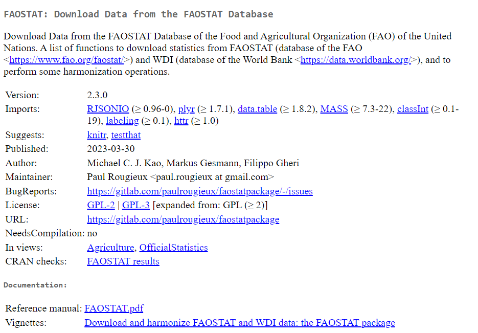
What is the FAOSTAT package?
- API wrapper that allows R users to use FAO functions
- Allows users to pull in FAOSTAT data
Why do R users need a package?
- Easily accessible documentation
- No need to convert json to R objects (tables)
Quick demo of pre-existing functionality
Custodianship
- Developed by FAO employees
- Currently maintained by Paul Rougieux at the European Commission
Existing documentation
- A single json file
- A word document
- Only covers a subset of functionality
Challenges
- Old API doesn’t work
- New API is largely undocumented
- Outdated functions
We need to get from here
To here
FAOSTAT 2.3.0
- Completed in March 2023 with 3 goals:
- Fix core functions
- Triage existing functions
- Describe all API endpoints
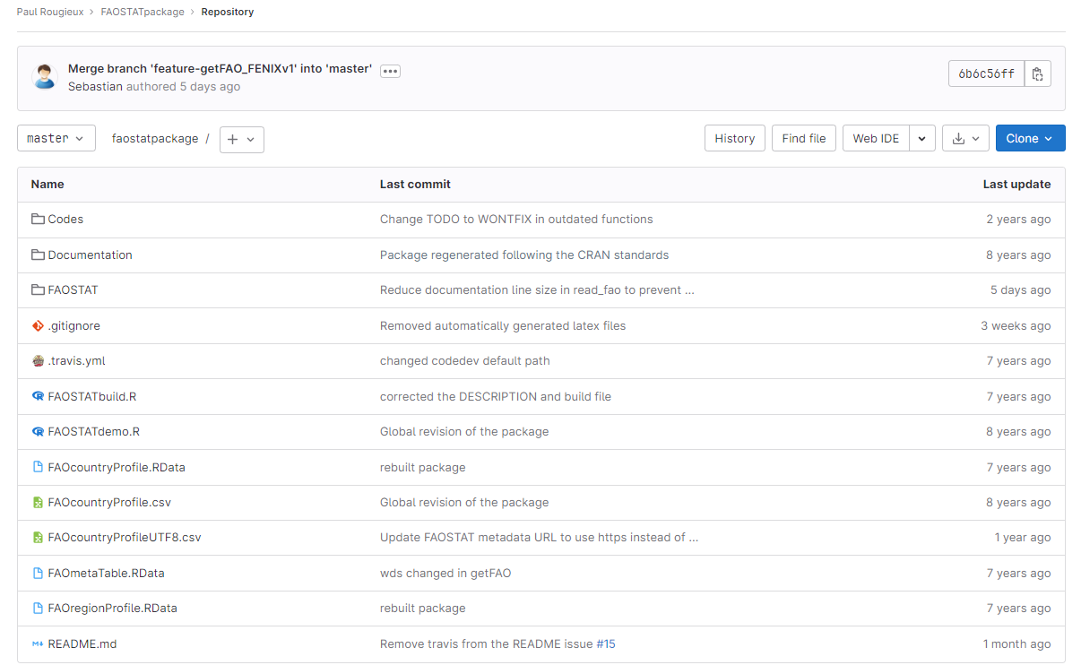
Triage existing functions
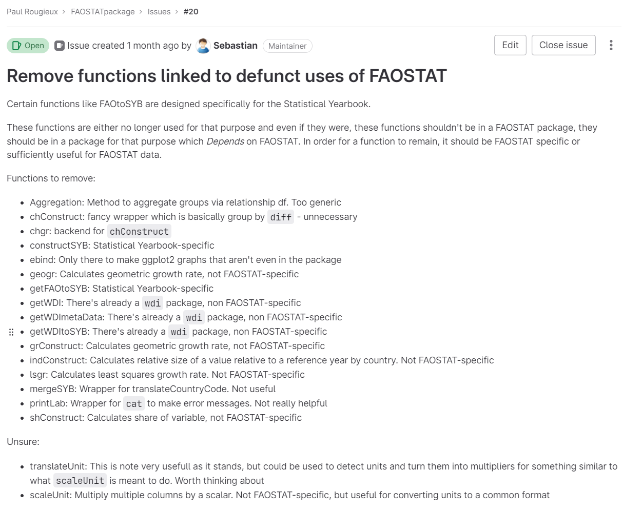
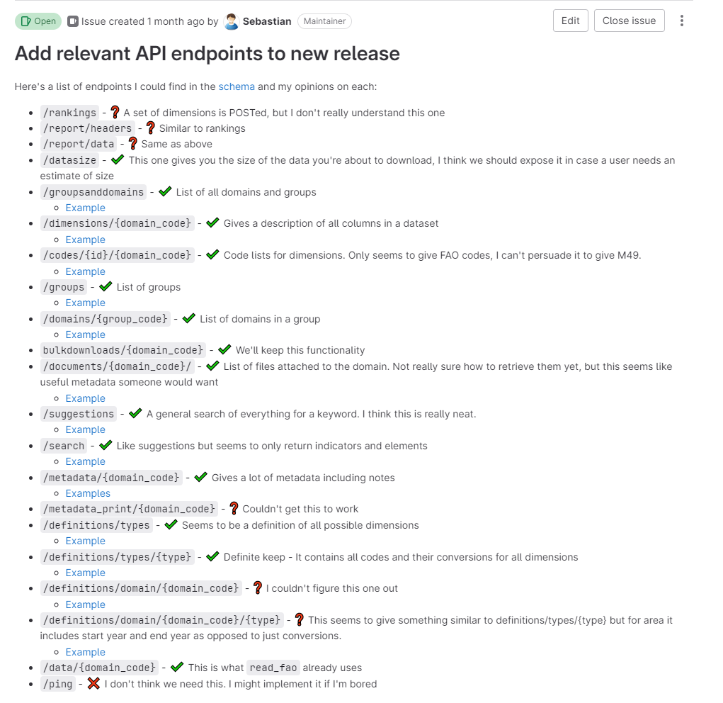
Describe all API endpoints
- Used json documentation
- Manually tested all the endpoints
- Wrote everything up on an issue page
It was a lot of work
API structure
flowchart TD
  Group --> Domain
  Dimension --> Codes
  Dimension --> Subdimensions
  Subdimensions --> Codes
  Domain --> Dimension
  Domain --> Data
  Domain --> BD[Bulk downloads]
  Domain --> Metadata
  Metadata --> Document
FAOSTAT 3.0.0
Implementing all of the changes we identified in 2.3.0
- Deprecating old functions
- Creating new structures
Now it works
read_fao(domain = "RL",
         area_codes = "8",
         element_codes = "5110",
         item_codes = "6620",
         year_codes = 2000:2020)
Domain.Code Domain Area.Code..M49. Area Element.Code
1 RL Land Use 28 Antigua and Barbuda 5110
2 RL Land Use 28 Antigua and Barbuda 5110
3 RL Land Use 28 Antigua and Barbuda 5110
4 RL Land Use 28 Antigua and Barbuda 5110
5 RL Land Use 28 Antigua and Barbuda 5110
6 RL Land Use 28 Antigua and Barbuda 5110
7 RL Land Use 28 Antigua and Barbuda 5110
8 RL Land Use 28 Antigua and Barbuda 5110
9 RL Land Use 28 Antigua and Barbuda 5110
10 RL Land Use 28 Antigua and Barbuda 5110
11 RL Land Use 28 Antigua and Barbuda 5110
12 RL Land Use 28 Antigua and Barbuda 5110
13 RL Land Use 28 Antigua and Barbuda 5110
14 RL Land Use 28 Antigua and Barbuda 5110
15 RL Land Use 28 Antigua and Barbuda 5110
16 RL Land Use 28 Antigua and Barbuda 5110
17 RL Land Use 28 Antigua and Barbuda 5110
18 RL Land Use 28 Antigua and Barbuda 5110
19 RL Land Use 28 Antigua and Barbuda 5110
20 RL Land Use 28 Antigua and Barbuda 5110
21 RL Land Use 28 Antigua and Barbuda 5110
Element Item.Code..CPC. Item Year.Code Year Unit Value Flag
1 Area F6620 Cropland 2000 2000 1000 ha 5 I
2 Area F6620 Cropland 2001 2001 1000 ha 5 I
3 Area F6620 Cropland 2002 2002 1000 ha 5 I
4 Area F6620 Cropland 2003 2003 1000 ha 5 I
5 Area F6620 Cropland 2004 2004 1000 ha 5 I
6 Area F6620 Cropland 2005 2005 1000 ha 5 I
7 Area F6620 Cropland 2006 2006 1000 ha 5 I
8 Area F6620 Cropland 2007 2007 1000 ha 5 I
9 Area F6620 Cropland 2008 2008 1000 ha 5 I
10 Area F6620 Cropland 2009 2009 1000 ha 5 I
11 Area F6620 Cropland 2010 2010 1000 ha 5 I
12 Area F6620 Cropland 2011 2011 1000 ha 5 I
13 Area F6620 Cropland 2012 2012 1000 ha 5 I
14 Area F6620 Cropland 2013 2013 1000 ha 5 I
15 Area F6620 Cropland 2014 2014 1000 ha 5 I
16 Area F6620 Cropland 2015 2015 1000 ha 5 I
17 Area F6620 Cropland 2016 2016 1000 ha 5 I
18 Area F6620 Cropland 2017 2017 1000 ha 5 I
19 Area F6620 Cropland 2018 2018 1000 ha 5 I
20 Area F6620 Cropland 2019 2019 1000 ha 5 I
21 Area F6620 Cropland 2020 2020 1000 ha 5 I
Flag.Description Note
1 Imputed value NA
2 Imputed value NA
3 Imputed value NA
4 Imputed value NA
5 Imputed value NA
6 Imputed value NA
7 Imputed value NA
8 Imputed value NA
9 Imputed value NA
10 Imputed value NA
11 Imputed value NA
12 Imputed value NA
13 Imputed value NA
14 Imputed value NA
15 Imputed value NA
16 Imputed value NA
17 Imputed value NA
18 Imputed value NA
19 Imputed value NA
20 Imputed value NA
21 Imputed value NADefunct functions
Future work
- Does it make sense to make a package for every API?
- Web-connectors are another approach
- Collecting AQUASTAT, Fisheries and other FAO data into one place would allow a single package to work for more data
Further reading
![]()